Blog Header
Monday, 12 February 2024
Provence Trip June/July 2023 - Part 6 Bormes les Mimosas
The village of Bormes les Mimosas, near Le Lavandou, is a few kilometres inland from its port, called La Favière, which was where we were camping. We have stayed at the Camp du Domaine several times before and it is right on the beach. It's one of the largest and most expensive campsites we have ever been to and doesn't even have a pool, but the sea swimming there is just fabulous as there's not a stone or pebble when you walk from the golden sandy beach right out into the water, which slopes shallowly. So we reckon it is worth a splurge every now and again for three or four days!
We took the bus up to the village which is in the hills and is one of the prettiest places I have ever visited, because it's just dripping in Bougainvillea, Plumbago and other flowering plants!
Our route from Entrevaux:
I love the ochre and terracotta colours of these buildings, especially with the pale green shutters, a common colour in Provence.
A good excuse to have lunch out!
Two old geezers sitting in the shade.
A wander around the ports of La Favière and Le Lavandou in the next post.
We took the bus up to the village which is in the hills and is one of the prettiest places I have ever visited, because it's just dripping in Bougainvillea, Plumbago and other flowering plants!
Our route from Entrevaux:
I love the ochre and terracotta colours of these buildings, especially with the pale green shutters, a common colour in Provence.
A good excuse to have lunch out!
Two old geezers sitting in the shade.
A wander around the ports of La Favière and Le Lavandou in the next post.
Wednesday, 7 February 2024
Provence Trip June/July 2023 - Part 5 St Martin Vesubie to Entrevaux
The next day we left Isola in the Tinee Valley and headed to Entrevaux. I'd forgotten I had marked out our routes on Google Maps and made screenshots of them, which would have been more helpful for you for the previous routes! The reason for the longer route below was because there were several gorges on the routes south that didn't sound like they would be possible in our motorhome.
Again I took photos with my phone out of the side window as we drove along.
Here we are coming into St Martin Vesubie. This town and those further down the valley suffered dreadfully from Storm Alex in 2020. About 600mm of rain (about a year's worth for some parts of France) fell in one day, resulting in mud slides and flash flooding in the narrow river valley, which caused roads and buildings to be washed away and loss of life. Even now, a lot remains to be rebuilt. The river bed was full of bulldozers and concrete blocks piled up. There were huge boulders everywhere which presumably had been washed down the valley. Hard to believe when the river itself was only a little stream when we went through - the power of water is really scary. There are some heartbreaking photos in this online gallery here.
Coming closer to that building, you can see how much of the bank was washed away and this poor building, whilst it still looks ok would have been condemned as it is far too dangerous to be lived in!
You can see if you click on the photo that the bridge is no longer there - just concrete stumps on either side. I can't actually see the stream here at all. We are driving over a new bridge whilst the photo was being taken.
Another view of what was left of the original bridge here, on the right side of the river bed.
This area looks like the banks have been built up and the river bed cleared of boulders.
Poor old house!
When we arrived at our campsite near Entrevaux we went for a walk beside the Var river to the little town. It was on this path where I saw the Southern Comma butterfly.
Entrevaux, which was a bit of a sleepy hollow to be honest. There is a castle up the top of the hill.
Here you can see the castle perched on top of the rock, with lovely zigzag paths leading all the way up to it. I had originally thought about going up there, but changed my mind when I saw just how far it was - and I think I'd have been going on my own anyway! 😀
From here we headed to the coast - to be followed in Part 6.
Again I took photos with my phone out of the side window as we drove along.
Here we are coming into St Martin Vesubie. This town and those further down the valley suffered dreadfully from Storm Alex in 2020. About 600mm of rain (about a year's worth for some parts of France) fell in one day, resulting in mud slides and flash flooding in the narrow river valley, which caused roads and buildings to be washed away and loss of life. Even now, a lot remains to be rebuilt. The river bed was full of bulldozers and concrete blocks piled up. There were huge boulders everywhere which presumably had been washed down the valley. Hard to believe when the river itself was only a little stream when we went through - the power of water is really scary. There are some heartbreaking photos in this online gallery here.
Coming closer to that building, you can see how much of the bank was washed away and this poor building, whilst it still looks ok would have been condemned as it is far too dangerous to be lived in!
You can see if you click on the photo that the bridge is no longer there - just concrete stumps on either side. I can't actually see the stream here at all. We are driving over a new bridge whilst the photo was being taken.
Another view of what was left of the original bridge here, on the right side of the river bed.
This area looks like the banks have been built up and the river bed cleared of boulders.
Poor old house!
When we arrived at our campsite near Entrevaux we went for a walk beside the Var river to the little town. It was on this path where I saw the Southern Comma butterfly.
Entrevaux, which was a bit of a sleepy hollow to be honest. There is a castle up the top of the hill.
Here you can see the castle perched on top of the rock, with lovely zigzag paths leading all the way up to it. I had originally thought about going up there, but changed my mind when I saw just how far it was - and I think I'd have been going on my own anyway! 😀
From here we headed to the coast - to be followed in Part 6.
Saturday, 3 February 2024
Provence Trip June/July 2023 - Part 4 La Col de la Bonette (Scenery)
The Col de la Bonette is on the stretch of D64 that links Jausiers, near Barcelonnette to the village of St Etienne de Tinée in the Alpes-Maritime dept, which eventually links Nice to Barcelonnette and beyond in the summer months when the col is open. Most of the road lies within the Mercantour National Park. Originally a mule track, transformed into a road in 1832, then classified imperial in 1860 by Emperor Napoleon III, the road as we know it was completed in 1964 but it took another ten years for the loop road around the Cime to be completed.
At 2,715 m the Col de la Bonette is one of the highest paved road passes in Europe; apparently if you allow for the extra loop road around the Cime de la Bonette, which reaches 2,802m, it is the highest paved through road. The loop road is, however, not a col (pass)! There are higher non through roads, there are higher passes and there are higher unpaved roads but there is one thing which is not disputable, and that is that it is a very high route indeed!
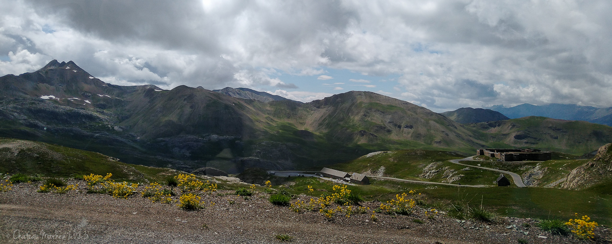
There are a number of abandoned military forts and bases up in the mountains as we are very close to the Italian border here and they stem from the days when France was protecting its Alpine borders from the Italians. You can see a fort in the following photo on the right - click to view larger.
You can see the loop road in the following two photos - not the obvious road below but up in the grey rocky area - and the Cime (which means peak) is at 2,860m. The Tour de France has included this pass a number of times in the past and will again this year.
I'm pretty sure this drift was actually just before we came to the col, further reinforcing our decision to miss the loop!
And down the other side.
Fourches Camp, another abandoned military site.
I didn't take so many photos coming down as going up. At this last place where we were able to stop the whole hillside was covered in Yellow Rattle (Rhinanthus minor).
Yellow Rattle.
I've never seen a Foxglove like this before - Large Yellow Foxglove (Digitalis grandiflora), native to southern Europe and Asia.
This day was, for me, the highlight of our two week trip - between the scenery and the alpine wildflowers it was absolutely outstanding. There were even butterflies at the beginning of the day, some of which I have shown on my Butterflies in Provence post. I can't wait to revisit the col, though on a warmer day might be nice!
We spent the night at Isola in the Tinée valley before continuing on our journey.
At 2,715 m the Col de la Bonette is one of the highest paved road passes in Europe; apparently if you allow for the extra loop road around the Cime de la Bonette, which reaches 2,802m, it is the highest paved through road. The loop road is, however, not a col (pass)! There are higher non through roads, there are higher passes and there are higher unpaved roads but there is one thing which is not disputable, and that is that it is a very high route indeed!
There are a number of abandoned military forts and bases up in the mountains as we are very close to the Italian border here and they stem from the days when France was protecting its Alpine borders from the Italians. You can see a fort in the following photo on the right - click to view larger.
You can see the loop road in the following two photos - not the obvious road below but up in the grey rocky area - and the Cime (which means peak) is at 2,860m. The Tour de France has included this pass a number of times in the past and will again this year.
We didn't actually do this loop - you don't have to as you can just ignore that extra section and start going downwards after the actual pass. I would have loved to have stopped there and climbed up to the top of the Cime, where there is an orientation table. Looking ahead though, we could see those snow drifts and were a bit unsure. It's not like we could have turned around on the road to come back and reversing a motorhome wasn't going to be great deal of fun! So we did the boring but sensible thing.
There wasn't much traffic and the road was well looked after and definitely ok to do in a 7m motorhome at the beginning of July. I'm not sure about travelling it during the school summer holidays though.
I'm pretty sure this drift was actually just before we came to the col, further reinforcing our decision to miss the loop!
And down the other side.
Fourches Camp, another abandoned military site.
I didn't take so many photos coming down as going up. At this last place where we were able to stop the whole hillside was covered in Yellow Rattle (Rhinanthus minor).
Yellow Rattle.
I've never seen a Foxglove like this before - Large Yellow Foxglove (Digitalis grandiflora), native to southern Europe and Asia.
This day was, for me, the highlight of our two week trip - between the scenery and the alpine wildflowers it was absolutely outstanding. There were even butterflies at the beginning of the day, some of which I have shown on my Butterflies in Provence post. I can't wait to revisit the col, though on a warmer day might be nice!
We spent the night at Isola in the Tinée valley before continuing on our journey.
Subscribe to:
Posts (Atom)